 |

 Northern Headwaters Region |
||
|
|
Overview of Environment and Archaeology Geography (map) Mapping the Northern Headwaters Topography and Environment Precontact Archaeology (site map) Historic Archaeology (site map) The Headwaters Area of northern Minnesota is known for its abundant woodlands and waterways. The most celebrated waterway there, the Mississippi River, flows through seven lakes and five counties (Clearwater, Hubbard, Beltrami, Cass, and Itasca) within its first 150 miles. There are no major or abrupt changes in elevation, and in that distance the river drops just 200 feet.
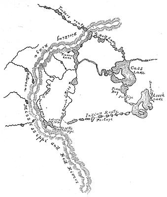
The Mississippi River has its beginnings at Lake Itasca in Clearwater County. Contained by a height-of-land that shapes its course, the infant river first flows north and east before turning southward towards the Twin Cities Area. Two notable streams that join the Mississippi in the Northern Headwaters area are the Turtle and Leech Lake rivers, each once thought by early explorers to be the main source of the great river. See: Itasca State Park for additional headwaters history.
|
||
|
|
|
||
|
|
While the Mississippi River flows south to the Gulf of Mexico, adjoining watersheds in Minnesota drain north to Hudson Bay and east to the Atlantic Ocean. |
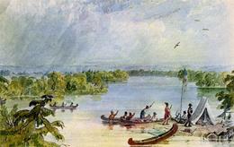
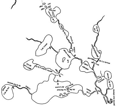
 Crossing the Turtle Lake - Lake Julia portage. |
|
|
 |
Lying at the head of these great out-flowing waterways, and between the Great Lakes and the Great Plains, northern Minnesota has long been an intersection for human migration and trade -- not a congested intersection, but a crossroads nonetheless.
|
|
|
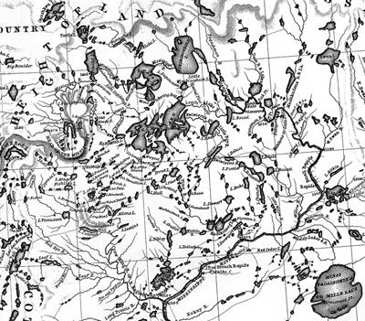
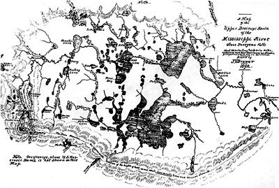
Archaeologists use early maps of the Northern Headwaters area to locate and study
specific sites there, like Buena Vista or Old Agency, or to better understand
things like place names, trade or transportation networks, settlement and
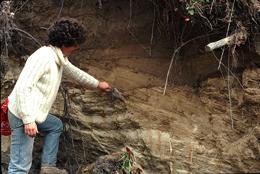
land-use patterns, and the distribution of natural resources. The physical landscape of the Northern Headwaters area was formed, in large part, by glacial ice and the ponding or runoff of glacial melt water. During the Wisconsin stage of glaciation, between 75,000 and 12,000 years ago, glaciers advanced across Minnesota several times and from several directions. |
|
|
The surface deposits left by these ice lobes often contain different kinds or quantities of rock, clay, and sand. Among glacial-related features seen in the Northern Headwaters area today are moraines, outwash plains, and lake basins.
|
|
|
|
See: Upper Mississippi Glacial Landscapes Exposed landscapes left by the retreating glaciers between about 13,000 and 11,000 years ago encouraged the formation of wind-blown soil deposits and an invasion of plants and animals. A succession of plant communities followed, ranging from the first tundra-like growth and spruce-birch woods to later upland forests dominated by pine and deciduous trees. The climate continued to moderate until about 7,000 years ago, entering a postglacial warm, dry period known as the Altithermal. During that time, water levels dropped and drainage channels deepened. In some areas of the Northern Headwaters, forest growth gave way to grassland openings. The advent of cooler, moister conditions about 5,000 years ago led again to increased water levels and forest cover and the establishment of modern plant communities.
|
|
|
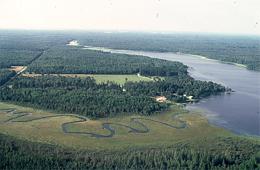
Today the Northern Headwaters is a patchwork mosaic of lakes, wetlands, grassy openings, and woods. Some of the larger lakes, like Cass, Leech, and Winnibigoshish, are maintained as reservoirs by the U.S. Corps of Engineers.
|
 |
|
|
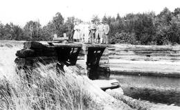
Early loggers also built temporary dams or made other facilities to manage the capture and flow of water. As a result of the many water-level fluctuations since the time of deglaciation, some cultural remains now are flooded and others lie on old beach ridges or terraces some distance from open water.
|
|
|
|
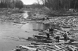 Loggers drive logs down river. Minnesota Historical Society photo. |
|
|
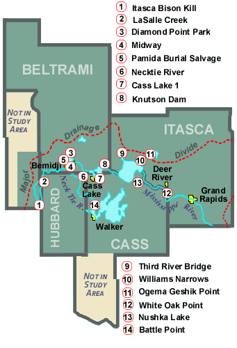
While early Paleo-Indian artifacts are rare in northern Minnesota, later Paleo-Indian projectile points have been found at some surface locations and in a few excavated sites. The Williams Narrows site, the Knutson Dam site, theHorseshoe Bay site, and the Pamida Burial Salvage Project site all appear to contain some Paleo-Indian components. The postglacial climate in the Minnesota area reached its maximum warmth and aridity during the Archaic cultural period. Archaic peoples were still semi-nomadic, but they began to develop greater regional cultural differences as their populations grew and they adapted to diverse environmental conditions. The Archaic site most extensively and systematically explored by archaeologists in the Northern Headwaters Area is the Itasca Bison Kill site on Nicollet Creek in Itasca State Park. Native American populations in the Mississippi Headwaters area reached their peak during Woodland times. Woodland sites or deposits are typically identified through the presence of ceramics. Ceramics made by different human groups or at different times varied in physical construction and appearance. Archaeologists have named several distinctive ceramic types found in the area, such as "Brainerd," "Laurel," "Blackduck," and "Sandy Lake," and they are using the pottery types and chronologies to define spacial and temporal relationships and settlement and land use practices of the various Woodland cultural groups. One Woodland site in the Northern Headwaters area where extensive archaeological work has been done is Ogema Geshik Point on the Bowstring River in Itasca County. Other Woodland sites in Itasca County are Williams Narrows, White Oak Point, where some of the earliest archaeology in the area was done, and Third River Bridge West, a spring fishery. In Cass County are Cass Lake 1, which has yielded one of the oldest dates for wild rice use in Minnesota, and Nushka Lake, an multicomponent Woodland site with a very late Archaic occupation. The Diamond Point Park, Midway Site, and Pamida Burial Salvage Project sites, all within the city of Bemidji, together hold signs of nearly 10,000 years of human presence and shifting cultures there. In Hubbard County south of Bemidji are Necktie River and LaSalle Creek, a single component site where Brainerd ware more than 3,000 years old has been found. Knutson Dam is in Beltrami County, where the Mississippi leaves Cass Lake. It is a Woodland site that also contains evidence of fur trade activities and historic Ojibwe occupation.
|
|
|
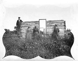 Unidentified abandoned homestead. John and Francis Allen Collection courtesy of Douglas Birk.
|
Non-Indian colonization increased after the American Revolution (1783) and was further stimulated with the close of the American Civil War (1865) when a growing stream of immigrant loggers and settlers appeared. |
|
|
Historic sites like old farmsteads and railroad grades are common in the Northern Headwaters area. To date, archaeologists have labored to document such properties and to develop contexts to assess their eligibility for listing on the National Register of Historic Places (NRHP).
|
 Old logging railroad grade.
|
|
|
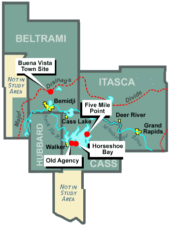
If properly studied, they can inform about postcontact activities in the Headwaters area and show how an enduring Euro-American presence there has affected Indian people and environments as well as the lives of the colonizers themselves. Among historic sites in the Northern Headwaters that have been studied by archaeologists are the abandoned town site of Buena Vista in Beltrami County, a trading post site at Horseshoe Bay on Leech Lake, and an old Indian Agency complex on Leech Lake, both in Cass County. Research leading toward on-site archaeology has also been done on a fur-trading post at Five Mile Point. The dominant historic components at each of these sites date to the middle or late 19th century. Back to the Northern Headwaters Region main page.
|