|
Click to enlarge image:
medium (575 pixels)
large (1000 pixels)
|
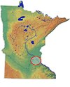
Location of 21AN106 in east-central Minnesota.
|

|
Click to enlarge image:
medium (575 pixels)
large (1000 pixels)
|
Location of 21AN106 between Crossways and Rondeau lakes.
|

|
Click to enlarge image:
medium (575 pixels)
large (1000 pixels)
|
Conical copper spear point excavated from 21AN106 in 1996. Drawing by Mike Beck, IMA Consulting.
|

|
Click to enlarge image:
medium (575 pixels)
large (1000 pixels)
|
Selected pottery excavated from 21AN106 in 1995.
|

|
Click to enlarge image:
medium (575 pixels)
large (1000 pixels)
|
Three-dimensional site map of 21AN106 showing the location of 1996 excavation units.
|

|
Click to enlarge image:
medium (575 pixels)
large (1000 pixels)
|
Probable surface hydrology of the Rice Creek area during the Mid-Holocene dry period (9,000-4,000 years ago). Lake levels are shown 10 feet lower than 1980 levels.
|

|
Click to enlarge image:
medium (575 pixels)
large (1000 pixels)
|
Probable surface hydrology of the Rice Creek area during the Late Holocene period (ca. 4,000 years ago). Lake levels are shown 5 feet lower than 1980 levels.
|

|
Click to enlarge image:
medium (575 pixels)
large (1000 pixels)
|
Probable surface hydrology of the Rice Creek area during the Late Holocene period (ca. 3,000 years ago). Lake levels are higher than 1980 levels.
|

|
Click to enlarge image:
medium (575 pixels)
large (1000 pixels)
|
Surface hydrology in 1847.
|

|
Click to enlarge image:
medium (575 pixels)
large (1000 pixels)
|
Surface hydrology in 1980.
|

|
Click to enlarge image:
medium (575 pixels)
large (1000 pixels)
|
Unidentified grass phytolith recovered from food residue on a ceramic sherd excavated from 21AN106 in 1996 (magnified 900 times).
|

|
Click to enlarge image:
medium (575 pixels)
large (1000 pixels)
|
Possible squash or gourd phytolith recovered from food residue on a ceramic sherd excavated from 21AN106 in 1996 (magnified 900 times).
|

|
Click to enlarge image:
medium (575 pixels)
large (1000 pixels)
|
Corn phytolith recovered from food residue on a ceramic sherd excavated from 21AN106 in 1996 (magnified 900 times).
|

|
Click to enlarge image:
medium (575 pixels)
large (1000 pixels)
|
Corn phytolith recovered from food residue on a ceramic sherd excavated from 21AN106 in 1996 (magnified 900 times).
|

|
Click to enlarge image:
medium (575 pixels)
large (1000 pixels)
|
Wild rice phytoliths recovered from food residue on a ceramic sherd excavated from 21AN106 in 1996 (magnified 400 times).
|

|
Click to enlarge image:
medium (575 pixels)
large (1000 pixels)
|
Interior surface of a ceramic rim sherd excavated from 21AN106 in 1996. The rim has been decorated by applying a cord-marked stick.
|

|
Click to enlarge image:
medium (575 pixels)
large (1000 pixels)
|
Exterior surface of a ceramic rim sherd excavated from 21AN106 in 1996. The surface has been decorated by applying a dentate stamp, forming patterns in vertical zones.
|

|
Click to enlarge image:
medium (575 pixels)
large (1000 pixels)
|
Fragment of a chipped stone scraping tool excavated from 21AN106 in 1996.
|

|
Click to enlarge image:
medium (575 pixels)
large (1000 pixels)
|
Exterior surface of a ceramic rim sherd excavated from 21AN106 in 1996. The surface has been decorated by applying a cord-marked stick and dentate stamp, forming patterns in vertical zones.
|

|
Click to enlarge image:
medium (575 pixels)
large (1000 pixels)
|
Scraper excavated from 21AN106 in 1996. The tool is made from Tongue River Silica, a type of chert that is commonly found in glacial deposits across Minnesota.
|

|
Click to enlarge image:
medium (575 pixels)
large (1000 pixels)
|
Retouched blade excavated from 21AN106 in 1996. The tool is made from Hixton Quartzite, a material that was derived from bedrock deposits in west-central Wisconsin.
|

|
Click to enlarge image:
medium (575 pixels)
large (1000 pixels)
|
Retouched blade excavated from 21AN106 in 1996. The tool is made from an unidentified type of chert.
|

|
Click to enlarge image:
medium (575 pixels)
large (1000 pixels)
|
View of 1996 excavations at 21AN106, facing southeast.
|

|
Click to enlarge image:
medium (575 pixels)
large (1000 pixels)
|
Small cluster of fire-cracked rock encountered during excavation of a 1-x-1-m unit.
|

|
Click to enlarge image:
medium (575 pixels)
large (1000 pixels)
|
View of 1996 excavations at 21AN106, facing east.
|

|
Click to enlarge image:
medium (575 pixels)
large (1000 pixels)
|
Excavators at work on a 1-x-1-m unit.
|

|
Click to enlarge image:
medium (575 pixels)
large (1000 pixels)
|
Excavators use trowels to carefully unearth a cluster of fire-cracked rock.
|

|
Click to enlarge image:
medium (575 pixels)
large (1000 pixels)
|
Excavators cover all open units at the end of each day to prevent damage from rainfall.
|

|
Click to enlarge image:
medium (575 pixels)
large (1000 pixels)
|
An excavator takes soil samples from column on the wall of an open unit. The samples were used to study the geologic processes that affected the landform upon which 21AN106 is located.
|

|
Click to enlarge image:
medium (575 pixels)
large (1000 pixels)
|
An excavator works on a block of adjacent 1-x-1-m units.
|

|
Click to enlarge image:
medium (575 pixels)
large (1000 pixels)
|
View of 1996 excavations in progress, facing west.
|

|
Click to enlarge image:
medium (575 pixels)
large (1000 pixels)
|
An excavator takes soil samples from column on the wall of an open unit. The samples were used to study the geologic processes that affected the landform upon which 21AN106 is located.
|

|
Click to enlarge image:
medium (575 pixels)
large (1000 pixels)
|
Small cluster of fire-cracked rock encountered during excavation of a 1-x-1-m unit.
|

|
Click to enlarge image:
medium (575 pixels)
large (1000 pixels)
|
Excavators use a transit to record surface elevations across the site. The elevations were later used to create a contour map of the site area.
|

|
Click to enlarge image:
medium (575 pixels)
large (1000 pixels)
|
A laptop computer was used to record ground-penetrating radar data in the field.
|

|
Click to enlarge image:
medium (575 pixels)
large (1000 pixels)
|
A technician pulls the ground-penetrating radar unit across the site.
|

|
Click to enlarge image:
medium (575 pixels)
large (1000 pixels)
|
A technician pulls the ground-penetrating radar unit across the site.
|

|
Click to enlarge image:
medium (575 pixels)
large (1000 pixels)
|
View of the ground-penetrating radar survey, facing southwest.
|

|
Click to enlarge image:
medium (575 pixels)
large (1000 pixels)
|
View of the ground-penetrating radar survey, facing northeast.
|

|
Click to enlarge image:
medium (575 pixels)
large (1000 pixels)
|
View of the ground-penetrating radar survey, facing east.
|

|
Click to enlarge image:
medium (575 pixels)
large (1000 pixels)
|
Recording data during the ground-penetrating radar survey.
|