
|
Figure 12.1 The Diamond Bluff mound group mapped by T.H. Lewis in 1887 (derived from Svec 1985).
120
180
260
400
575
1000
|

|
Figure 12.2 Brower's map of the Diamond Bluff terrace. The Stars identify village areas (derived from Brower 1903).
120
180
260
400
575
1000
|

|
Figure 12.3 Squier's map of the mounds on the north end of the Diamond Bluff terrace (derived from Squier 1914).
120
180
260
400
575
1000
|

|
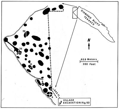
Figure 12.4 The mounds excavated by the Wisconsin Archaeological Survey in 1948 (base map from Maxwell 1950a).
120
180
260
400
575
1000
|

|
Figure 12.8 Pottery motifs and rim profiles recovered by the Wisconsin Archaeological Survey at Diamond Bluff (derived from field notes and Hall 1962, Vol. III).
120
180
260
400
575
1000
|

|
Figure 12.10 The Wisconsin Archaeological Survey text excavation in the village area.
120
180
260
400
575
1000
|

|
Figure 12.11 Plan view of village excavation by the University of Wisconsin-Milwaukee.
120
180
260
400
575
1000
|

|
Figure 12.12 Silvernale ware recovered in the village area excavated by the University of Wisconsin-Milwaukee.
120
180
260
400
575
1000
|

|
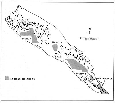
Figure 12.13 Site areas on the Diamond Bluff terrace by the Institute for Minnesota Archaeology survey (derived from Wendt and Dobbs 1989).
120
180
260
400
575
1000
|

|
Figure 12.14 Artifacts attributed to the Southeastern Ceremonial Complex found at Diamond Bluff. (A) Copper mace pendant, (B-B’) marine shell God Mask (derived from Beadle 1942; Lawshe 1947), (C) mace pendant motif on pottery in University of Wisconsin-Milwaukee collection.
120
180
260
400
575
1000
|


