 |
Click to enlarge image:
medium (575 pixels)
large (1000 pixels)
|
Figure 1. Map of the Central Minneapolis
Riverfront showing the route of the new West River Parkway (dark line, dashed where not
constructed) and the location of the Hennepin Avenue bridge (circled).
|
 |
Click to enlarge image:
medium (575 pixels)
large (1000 pixels)
|
Figure 2: Stylized cross-sectional drawings of a
breastshot grist mill (left) and a flutter wheel sawmill (right) from Ballard (1984). The
basic technology depicted here was probably similar to that used in the government mills
at St. Anthony Falls following the guide of Evans (1807).
|
 |
Click to enlarge image:
medium (575 pixels)
large (1000 pixels)
|
Figure 3: Fuller (1873) map of the west side
waterpower canal showing the adjacent mills and subterranean tailraces (dashed lines).
|
 |
Click to enlarge image:
medium (575 pixels)
large (1000 pixels)
|
Figure 4a: Typical turbine arrangement from
Howard (1976)..
|
 |
Click to enlarge image:
medium (575 pixels)
large (1000 pixels)
|
Figure 4b: Side view of the Pillsbury B Mill
turbine with the turbine tube embedded in the bedrock.
|
 |
Click to enlarge image:
medium (575 pixels)
large (1000 pixels)
|
Figure 5: Detail of 1880 map from Greenleaf
(1887) showing the waterpower systems on the east side and islands at St. Anthony Falls.
An overhead cable extends across the St. Anthony millpond from the sawmill platform to
Nicollet Island (far left). Another overhead cable extends up 3rd Avenue SE (top). A line
shaft powers the factories on Main Street above the platform.
|
 |
Click to enlarge image:
medium (575 pixels)
large (1000 pixels)
|
Figure 6: Cross-section of the east channel of
St. Anthony Falls showing the turbines, tailraces, and a tower drive for an overhead cable
(from Greenleaf 1887).
|
 |
Click to enlarge image:
medium (575 pixels)
large (1000 pixels)
|
Figure 7: Cumulative map of the waterpower
industries at St. Anthony Falls.
|
 |
Click to enlarge image:
medium (575 pixels)
large (1000 pixels)
|
Figure 8: Cumulative map of lumber milling
industries at St. Anthony Falls.
|
 |
Click to enlarge image:
medium (575 pixels)
large (1000 pixels)
|
Figure 9: Chart showing the growth and decline
of lumber milling and flour milling in Minneapolis in relation to population growth (from
Borchert et al. 1983).
|
 |
Click to enlarge image:
medium (575 pixels)
large (1000 pixels)
|
Figure 10: Shevlin-Carpenter (North Star)
Sawmill from the 1892 Rascher Atlas.
|
 |
Click to enlarge image:
medium (575 pixels)
large (1000 pixels)
|
Figure 11: Typical layout of a stone flour mill
of 1878 from the Northwestern Miller (September 7, 1894). The basement contains the
drive equipment, the first flour has mill stones, the middle floors have purifiers and
bolters, and the top floor has dust collectors.
|
 |
Click to enlarge image:
medium (575 pixels)
large (1000 pixels)
|
Figure 12: End view and top view of the
Northwestern Consolidated Elevator, one of the last of the old style elevators built in
the St. Anthony Falls milling district. Note the multiple wooden bins.
|
 |
Click to enlarge image:
medium (575 pixels)
large (1000 pixels)
|
Figure 13: Cutaway view of a typical elevator of
the late nineteenth century. Grain is brought in by rail (1) and weighed (2), then dumped
into a hopper (3). A conveyor belt with cups then transports the grain to the head (4) at
the top of the elevator where it is directed by a movable spout (5) to individual bins
(6). The bins are funnel shaped at the bottom allowing downloading by gravity.
|
 |
Click to enlarge image:
medium (575 pixels)
large (1000 pixels)
|
Figure 14: Cumulative map of the grain milling
industries at St. Anthony Falls.
|
 |
Click to enlarge image:
medium (575 pixels)
large (1000 pixels)
|
Figure 15: Drawing of the Minnesota Ironworks
looking south (1871-72 City Directory).
|
 |
Click to enlarge image:
medium (575 pixels)
large (1000 pixels)
|
Figure 16: The Pray Manufacturing complex from
the 1885 Sanborn Atlas. Note several smaller iron works towards the lower right.
|
 |
Click to enlarge image:
medium (575 pixels)
large (1000 pixels)
|
Figure 17: Cumulative map of the ironworking
industries at St. Anthony Falls.
|
 |
Click to enlarge image:
medium (575 pixels)
large (1000 pixels)
|
Figure 18: The North Star Woolen Mill from an
1890 update of the 1885 Sanborn Atlas. The waterpower canal is beneath 1st Street at the
top.
|
 |
Click to enlarge image:
medium (575 pixels)
large (1000 pixels)
|
Figure 19a: The Heinrich Brewery from the 1885
Sanborn Atlas.
|
 |
Click to enlarge image:
medium (575 pixels)
large (1000 pixels)
|
Figure 19b: The Noerenberg Breweryfrom the 1885
Sanborn Atlas.
|
 |
Click to enlarge image:
medium (575 pixels)
large (1000 pixels)
|
Figure 20: Cross-section of a typical late
nineteenth century brewery (from the Western Brewer October 1904). The main
sections moving left to right are the stock house, brewhouse, mill house, and office.
|
 |
Click to enlarge image:
medium (575 pixels)
large (1000 pixels)
|
Figure 21a: The Chicago, St. Paul, Minneapolis,
and Omaha RR Roundhouse from the 1892 Rascher Atlas.
|
 |
Click to enlarge image:
medium (575 pixels)
large (1000 pixels)
|
Figure 21b: The Union Depot (bottom) from the
1892 Rascher Atlas.
|
 |
Click to enlarge image:
medium (575 pixels)
large (1000 pixels)
|
Figure 22: Typical streetcar rails and paving
methods used in Minneapolis in the late nineteenth century.
|
 |
Click to enlarge image:
medium (575 pixels)
large (1000 pixels)
|
Figure 23: The Minneapolis Gas Works from the
1912 Sanborn Atlas.
|
 |
Click to enlarge image:
medium (575 pixels)
large (1000 pixels)
|
Figure 24: Bohemian Flats from the 1892 Foote
Atlas. Note the small, closely spaced houses.
|
 |
Click to enlarge image:
medium (575 pixels)
large (1000 pixels)
|
Figure 25: Locations of the major excavated
archaeological sites along the central Minneapolis riverfront.
|
 |
Click to enlarge image:
medium (575 pixels)
large (1000 pixels)
|
Figure 26: Locations of 1983 West River Parkway
test units in the northern half of the Bassetts Creek Area. The C,SP,M and O RR Roundhouse
is at the right.
|
 |
Click to enlarge image:
medium (575 pixels)
large (1000 pixels)
|
Figure 27: Chicago, St. Paul, Minneapolis, and
Omaha RR Roundhouse plan from the 1983 West River Parkway excavations (from Tordoff 1984).
The turntable is at the left and the repair bays at the right.
|
 |
Click to enlarge image:
medium (575 pixels)
large (1000 pixels)
|
Figure 28: Side view and end view of a repair
bay of the C,SP,M and O RR Roundhouse excavated in 1983 (from Tordoff 1984).
|
 |
Click to enlarge image:
medium (575 pixels)
large (1000 pixels)
|
Figure 29: Locations of 1983 West River Parkway
test units in the southern half of the Bassetts Creek Area. The North Star Sawmill is at
the top center with West Side Power Plant to the left of the sawmill.
|
 |
Click to enlarge image:
medium (575 pixels)
large (1000 pixels)
|
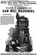
Figure 30: Drawing of a gang saw produced by the
North Star Ironworks from the Mississippi Valley Lumberman May 21, 1886. Note the
massive base similar to the one found in 1983 at the North Star Sawmill (Plate 1).
|
 |
Click to enlarge image:
medium (575 pixels)
large (1000 pixels)
|
Figure 31: North wall of the Pacific Sawmill
exposed by the 1983 West River Parkway survey (from Tordoff 1984). The concrete pedestals
are from the Great Northern Depot trainshed.
|
 |
Click to enlarge image:
medium (575 pixels)
large (1000 pixels)
|
Figure 32: Locations of the 1983 West River
Parkway test units in the Gateway Area. Moving left to right are the Pacific Sawmill, the
North Gateway Refuse Deposit, the Hennepin Avenue Bridges, the Union Depot, and the
Gateway Residential Area.
|
 |
Click to enlarge image:
medium (575 pixels)
large (1000 pixels)
|
Figure 33: Profile of Excavation Unit 60 in the
Gateway Residential Area (from Tordoff 1984). The dark deposit is the trash midden.
|
 |
Click to enlarge image:
medium (575 pixels)
large (1000 pixels)
|
Figure 34: East wall of the Union Depot
excavated in 1983 (from Tordoff 1984).
|
 |
Click to enlarge image:
medium (575 pixels)
large (1000 pixels)
|
Figure 35: Locations of the 1983 West River
Parkway test units in the northern part of the West Side Mill District.
|
 |
Click to enlarge image:
medium (575 pixels)
large (1000 pixels)
|
Figure 36: Locations of the 1983 West River
Parkway test units in the northern part of the Gasworks Bluff Area.
|
 |
Click to enlarge image:
medium (575 pixels)
large (1000 pixels)
|
Figure 37: Locations of the 1983 West River
Parkway test units in the northern part of Bohemian Flats.
|
 |
Click to enlarge image:
medium (575 pixels)
large (1000 pixels)
|
Figure 38: Locations of the 1983 test units in
the southern part of Bohemian Flats. The gas tanks had been removed by the time of the
excavations. The Heinrich Brewery is at the upper right.
|
 |
Click to enlarge image:
medium (575 pixels)
large (1000 pixels)
|
Figure 39: Top view of floors and foundation
walls exposed by the 1983 excavations at the Heinrich Brewery (from Tordoff 1984).
|
 |
Click to enlarge image:
medium (575 pixels)
large (1000 pixels)
|
Figure 40: Final site plan of the 1985
excavations at the Hennepin Avenue Bridge (from Tordoff and Clouse 1985). The black dots
were existing approach bridge support columns. The suspension bridge tower bases are
towards the top (1854 bridge on right) and the anchor tunnels are at the bottom.
|
 |
Click to enlarge image:
medium (575 pixels)
large (1000 pixels)
|
Figure 41: Test locations in the vicinity of the
Fuji-Ya restaurant in 1986 (from Tordoff 1986).
|
 |
Click to enlarge image:
medium (575 pixels)
large (1000 pixels)
|
Figure 42: Test units in the Fuji-Ya parking lot
excavated in 1986 (from Tordoff 1986).
|
 |
Click to enlarge image:
medium (575 pixels)
large (1000 pixels)
|
Figure 43: Test excavation at the Palisade Mill
in 1986 (from Tordoff 1986).
|
 |
Click to enlarge image:
medium (575 pixels)
large (1000 pixels)
|
Figure 44: Top view of 1986 excavation of the
Chicago, St. Paul, Minneapolis, and Omaha RR Roundhouse (from Tordoff and Clouse 1987).
|
 |
Click to enlarge image:
medium (575 pixels)
large (1000 pixels)
|
Figure 45: Top view of 1986 excavations at the
Pacific Sawmill showing the log slide on the left and the east wall on the right (from
Tordoff and Clouse 1987).
|
 |
Click to enlarge image:
medium (575 pixels)
large (1000 pixels)
|
Figure 46: Top view of the masonry pedastals
exposed by the 1986 excavations at the south end of the Gateway Residential Area (from
Tordoff and Clouse 1987).
|
 |
Click to enlarge image:
medium (575 pixels)
large (1000 pixels)
|
Figure 47: Top view of the City Waterworks
foundation walls exposed by the 1986 excavations (from Tordoff and Clouse 1987).
|
 |
Click to enlarge image:
medium (575 pixels)
large (1000 pixels)
|
Figure 48: South face of the west side canal
gates exposed by the 1986 excavations (from Tordoff and Clouse 1987).
|
 |
Click to enlarge image:
medium (575 pixels)
large (1000 pixels)
|
Figure 49: Locations of east side suspension
bridge features exposed by the 1988 monitoring of the Hennepin Avenue Bridge construction
on Nicollet Island.
|
 |
Click to enlarge image:
medium (575 pixels)
large (1000 pixels)
|
Figure 50: Top view of the 1989 excavations at
the Heinrich Brewery (from Szondy and Clouse 1990). The brewery foundations are in the
unit at the right.
|
 |
Click to enlarge image:
medium (575 pixels)
large (1000 pixels)
|
Figure 51: Top view schematic of the Heinrich
Brewery caves explored in 1989 (from Szondy and Clouse 1990).
|
 |
Click to enlarge image:
medium (575 pixels)
large (1000 pixels)
|
Figure 52: Top view of the Coon and Clapp Woolen
Mill/Empire Flour Mill/Pillsbury B Elevator and tailrace excavations from 1989 (from
Szondy and Clouse 1990).
|
 |
Click to enlarge image:
medium (575 pixels)
large (1000 pixels)
|
Figure 53: Tailrace tunnels at the north end of
the West Side Mill District. The main tailrace in the center runs beneath 1st Street. The
Columbia Mill, Bassett Sawmill, and City Water Works turbines are in the upper left, the
Crown Mill turbines are in the left center, and the Standard Mill turbine in the lower
center. The Empire Mill/Pillsbury B Elevator turbine is in the upper right.
|
 |
Click to enlarge image:
medium (575 pixels)
large (1000 pixels)
|
Figure 54: Study area of the Riverfront
Development Coordination Board (from Berman 1980).
|
 |
Click to enlarge image:
medium (575 pixels)
large (1000 pixels)
|
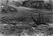
Plate 1: Large machinery footing uncovered by
the 1983 West River Parkway excavations at the North Star Sawmill.
|
 |
Click to enlarge image:
medium (575 pixels)
large (1000 pixels)
|
Plate 2: Tower base of the 1854 suspension
bridge and Union Depot foundations uncovered by the 1985 Hennepin Avenue bridge
excavations.
|
 |
Click to enlarge image:
medium (575 pixels)
large (1000 pixels)
|
Plate 3: Tower bases of the 1876 suspension
bridge uncovered by the 1985 Hennepin Avenue Bridge excavations.
|
 |
Click to enlarge image:
medium (575 pixels)
large (1000 pixels)
|
Plate 4: Back wall and repair bays of the
Chicago, St. Paul, Minneapolis, and Omaha RR Roundhouse uncovered by the 1986 West River
Parkway excavations.
|
 |
Click to enlarge image:
medium (575 pixels)
large (1000 pixels)
|
Plate 5: East wall of the Pacific Sawmill
exposed by the 1986 West River Parkway excavations.
|
 |
Click to enlarge image:
medium (575 pixels)
large (1000 pixels)
|
Plate 6: Log slide of the Pacific Sawmill
uncovered by the 1986 West River Parkway excavations.
|
 |
Click to enlarge image:
medium (575 pixels)
large (1000 pixels)
|
Plate 7: Masonry pedestals uncovered at the
south end of the Gateway Residential Area by the 1986 West River Parkway excavations.
|
 |
Click to enlarge image:
medium (575 pixels)
large (1000 pixels)
|
Plate 8: North face of the west side waterpower
canal gates uncovered by the 1986 West River Parkway excavations.
|
 |
Click to enlarge image:
medium (575 pixels)
large (1000 pixels)
|
Plate 9: Looking south at the east wall of the
West Side Power plant exposed by the 1986 construction on the West River Parkway.
|
 |
Click to enlarge image:
medium (575 pixels)
large (1000 pixels)
|
Plate 10: Looking west at the east side tower
bases of the 1876 suspension bridge exposed by the 1988 construction on the Hennepin
Avenue Bridge.
|
 |
Click to enlarge image:
medium (575 pixels)
large (1000 pixels)
|
Plate 11: Looking south at the east side anchor
housings of the 1876 suspension bridge exposed by the 1988 construction on the Hennepin
Avenue Bridge.
|
 |
Click to enlarge image:
medium (575 pixels)
large (1000 pixels)
|
Plate 12: Downstream, east side anchor link bars
of the 1854 suspension bridge exposed by the 1988 construction on the Hennepin Avenue
Bridge.
|
 |
Click to enlarge image:
medium (575 pixels)
large (1000 pixels)
|
Plate 13: Brick floor and masonry foundation
walls of the Heinrich Brewery exposed during the 1989 West River Parkway excavations.
|
 |
Click to enlarge image:
medium (575 pixels)
large (1000 pixels)
|
Plate 14: Excavations in 1989 at the west side
tailraces near the back of the Empire Mill/Pillsbury B Elevator.
|


