 |

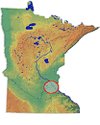
 Twin Cities Metro Area |
|||||||||||||||||||||
|
|
| |||||||||||||||||||||
|
|
Until the early 1930s Spring Lake, just south of Pine Bend and opposite Grey
Cloud Island, was a marshy area fed by springs and separated from the
Mississippi by a broad bar of wooded land. With the raising of the river
level by the Hastings dam, Spring Lake was flooded and became a part of the
Mississippi. The resulting erosion of the banks, combined in the early 1950s
with a proposed industrial development at the upper end of the lake near Pine
Bend, threatened to destroy a number of early Indian sites. Therefore between
1953 and 1958 the Science Museum of Minnesota conducted an extensive program
of salvage archaeology in the area.
 Seven sites were excavated or tested, of which the principal ones (21DK1, 2, 4, 5, 6 and 21WA1, 9) were on the southeast shore of Spring Lake and the eastern tip of Lower Grey Cloud Island. The results were recorded in a series of four reports.
|
|
|
Ancient occupation had long been suspected because of the large number of mound groups in the area, and mounds on Grey Cloud Island had been tested by University of Minnesota archaeologists in 1947. Investigation in the 1950s of nearby habitation sites revealed that permanent or seasonal settlements had existed there from Early Woodland to Mississippian times.
|
 This crushed pot, found at the Sorg site (21DK1), was classified as "Sorg Banded Dentate". The grit-tempered material is relatively thick. The vessel is 18 inches high.
|
|
|
|
|
|

|
The greatest number of artifacts represented the Middle Woodland period (2600 -- 1100 years ago), with a diminishing number of Late Woodland and Mississippian or Oneota examples.
The comparatively small amount of pottery showed similarities in style to that
found in areas farther south and east. Carbon 14 dating, then in its early
stages, suggested a date of 800 years ago plus or minus 200 years for a cobblestone
hearth found at one of the upper levels on the Sorg site.
|
|
|
|